Detail
Tangggal iklan:
Kota: Jakarta
Kondisi: Baru
Penjual

Nama: jagur Bandi
Terdaftar sejak: 7 Mei 2012
Status:

Facebook: jagur.bandy
No Telpon: 0213-XXXX-XXXX
No Handphone: 0838-XXXX-XXXX
CV.AURELINDO HUB. 021 3321 3131DEALER RESMI TELEPON SATELIT, GPS & ALAT SURVEY LAINNYA
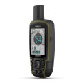
Portable GPS Garmin GPS MAP 78s 2.6 inch 3-Axis Compass track Naútico – GPSProduct DescriptionGPS Navigator Garmin GPSMAP 78s Proof Water Sports Water ‘with Screen 2.6 Inches Color Viewfinder
Perfect for water sports or boating, the Garmin GPSMAP 78s is the complete GPS, waterproof, with a 2.6-inch color display screen always leave you on the right track. ‘s GPSMAP 78s floats which facilitates be found if dropped in the water during her performance, is all rubberized sides, which makes it much more robust and sturdy.
Internal memory of 1.7 GB and still have input memory card (SD Card) for you to broaden your maps. Have barometric altimeter and 3-axis compass. GPSMAP 78s Garmin antenna has high sensitivity and HotFix ™ satellite prediction determining your position quickly and accurately, maintaining accurate information even under dense and deep valleys toppings, you can count on GPSMAP 78 whenever you need. This GPS has preloaded world base map.Specification:
• Unit dimensions: 6.6 x 15.2 x 3.0 cm• Display Size: 2.6 inches• Display resolution: 160 x 240 pixels• Display type: transflective, 65-K Color TFT• Battery: 2 AA batteries (not included ) – recommended NiMH or Lithium• Battery life: Up to 20 hours• Waterproof• Floats in water• High-sensitivity receiver• Compatible with USB interface and NMEA 0183• Basemap• Electronic compassBarometric altimeter •• Capacity include maps• Internal Memory: 1.7 GB• Accepts data cards – microSD ™ (not included)• Record up to 2000 Charts, Favourites and Locations• Records up to 200 routes• Track log: 10,000points • Register 200 Route 200• Automatic routing – routing on roads bend to bend with optional mapping for detailed roads• Can be easily used for geocaching• Custom maps compatible• Photo navigation – navigate to geotagged photos Calendar • Hunting and Fishing• Information about the sun and moon• Tide tables
Area calculation •• POI – ability to add additional points of interest• Picture Viewer• Compatible with Garmin Connect ™ – the online community where you analyze, categorize and share data• Supports satellite images (Required to signature Birdseyes package)• Transfer unit to unit that shares data wirelessly with similar units Availability to add maps: Possible to add maps:. nautical, topographic and road so that your GPS is complete and accompany you on any occasion Geocaching: Allows you download geocaches and details straight to the unit, store and display key information, including location, terrain, difficulty, hints and descriptions. Just upload the GPX file and start using.
Garmin Connect: . Garmin online community that allows you to record, track and share your adventures with other Garmin usersKit Comprising of:
• GPSMAP 78 Wrist Cord• USB Cable •• Manual
KAMI JUGA MENJUAL BERBAGAI MACAM TELEPON SATELIT SEPERTI:- TELEPON SATELLITE R 190- TELEPON SATELLITE BYRU MARINE FR 190- TELEPON SATELLITE PASTI TELUM- TELEPON SATELLITE PASTI FR 190- TELEPON SATELLITE THURAYA FIXED MARINE S-100- TELEPON SATELLITE THURAYA SO-2510- TELEPON SATELLITE THURAYA SG 2520- TELEPON SATELLITE THURAYA XT- TELEPON SATELLITE THURAYA FDU 3500- TELEPON SATELLITE IRIDIUM 9555- TELEPON SATELLITE ISATPHONE PROGaransi 1 Tahun
DAN ACCESSORIESNYA SEPERTI:- KARTU PERDANA BYRU / PASTI / BYRU MARINE- BATERAI R 190 / BATERAI THURAYA- CHARGER R 190- CIGARETLIGHTER R 190- ANTENNA EXTERNAL R 190 / Thuraya / Inmarsat- VOUCHER ISI ULANG BYRU / PASTI / INMARSAT
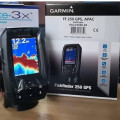
Serta Menjual Berbagai Macam GPS Garmindan bergaransi resmi 1 tahun + bebas ongkos kirim daerah DKI Jakarta.HARGA PROMO :- GARMIN Gpsmap 60 series , 60 Csx, 60i- GARMIN Gpsmap 76 series , 76 Csx, 76cx, 62s, 78s- GARMIN Gpsmap 585- Gps Montana 600, 650, 650t- Gps Etrex series , H / vista- Gps Mio (Navigasi) moov s500, moov s550- Gps Nuvi 1250, 1350, 1690, 1460 (Navigasi)- Gps Oregon 300, oregon 550 (NEW)- Gps colorado 300, 300i- Gps Magelan,Gps Triton 200,Triton 300,Triton 400,Triton 500,Triton 1500,Triton 2000- Trimble Juno SB, Juno SC- Gps Tracking Adlernav V400- Fishfinder 160c, 160ci, 400c, 420s, 421s (untuk mancing & berlayar)- GPS NAVIGASI DIGI-IN G007, G029, G030
Menerima Service GPS dan Telepon Satelit.
Specification satellite phone THURAYA XT
Size ; 128 x 53 x 26.5mm (hxwxd)Weight : 193gDisplay : 2” / 262K outdoor colour displayGmPRS Down/Up Speed : 60/15 kbpsFax and Data : 9.6 kbpsBattery Life : Talk time up to 6 hours and standby time up to 80 hours*PC compatibility : Windows Vista, Windows XP, Windows NT, Windows 2000External Interfaces : Data Cable (UDC) with USB connector, Ear Jack, DC PowerLanguages : Arabic, Chinese**, English, Farsi, French, German, Hindi, Italian, Russian, Spanish, Turkish, Portugese and Urdu
GRATIS BIAYA PENGIRIMAN UNTUK WILAYAh DKI JAKARTA
UNTUK INFORMASI DAN PEMESANAN SEGERA HUBUNGI :
AURELINDOROXY SQUARE Lantai GROUND BLOK B.7 NMR.5JL.KYAI TAPA NO.1 GROGOL - JAKARTA BARAT 11440
tlp.: 021-33213131fax / Telp : 021-5698 2164Hp : 0878 81 858 138Contac Person : NANO KARNO
YM : aurelindo69@yahoo.comweb : http://www.aurelindo.comemail : aurelindo69@yahoo.com


 English